Since 1970, more than a third of the world’s wetlands have been lost, at a rate three times faster than forest loss. To help governments and funders prioritize wetlands in need of protection or restoration, the global nonprofit Wetlands International has launched the new Wetland Atlas.
The interactive atlas integrates spatial information on different wetlands with data on their climate mitigation potential, how many people depend on them, and their protection status, the nonprofit said in a press release. Most of the other maps offer only raw data on the extent of wetlands.
Currently, the atlas focuses on the Sahel and the Horn of Africa, regions where wetlands are increasingly vulnerable. “Wetlands account for less than 10% of the area of the Sahel, but they are home of more than 75% of the population and directly support more than 85% of GDP,” Karounga Keita, Sahel director, Wetlands International, told Mongabay.
According to Richard Lee, Wetlands International’s communications director, the tool addresses a major hurdle called “wetland blindness,” where decision-makers undervalue areas like rivers, lakes and peatlands.
“Wetlands are invariably seen through a blinkered lens, which views rivers as just pipes for water, lakes as stores to be pumped dry and polluted, and other wetlands as ‘wastelands’ to be converted,” Lee told Mongabay by email. “This view neglects all the other values of healthy wetlands from food security to flood reduction, cultural significance to climate mitigation and adaptation.”
To create the new platform, researchers at Wetlands International combined information on biophysical, socioeconomic and policy aspects of wetlands from scattered datasets.
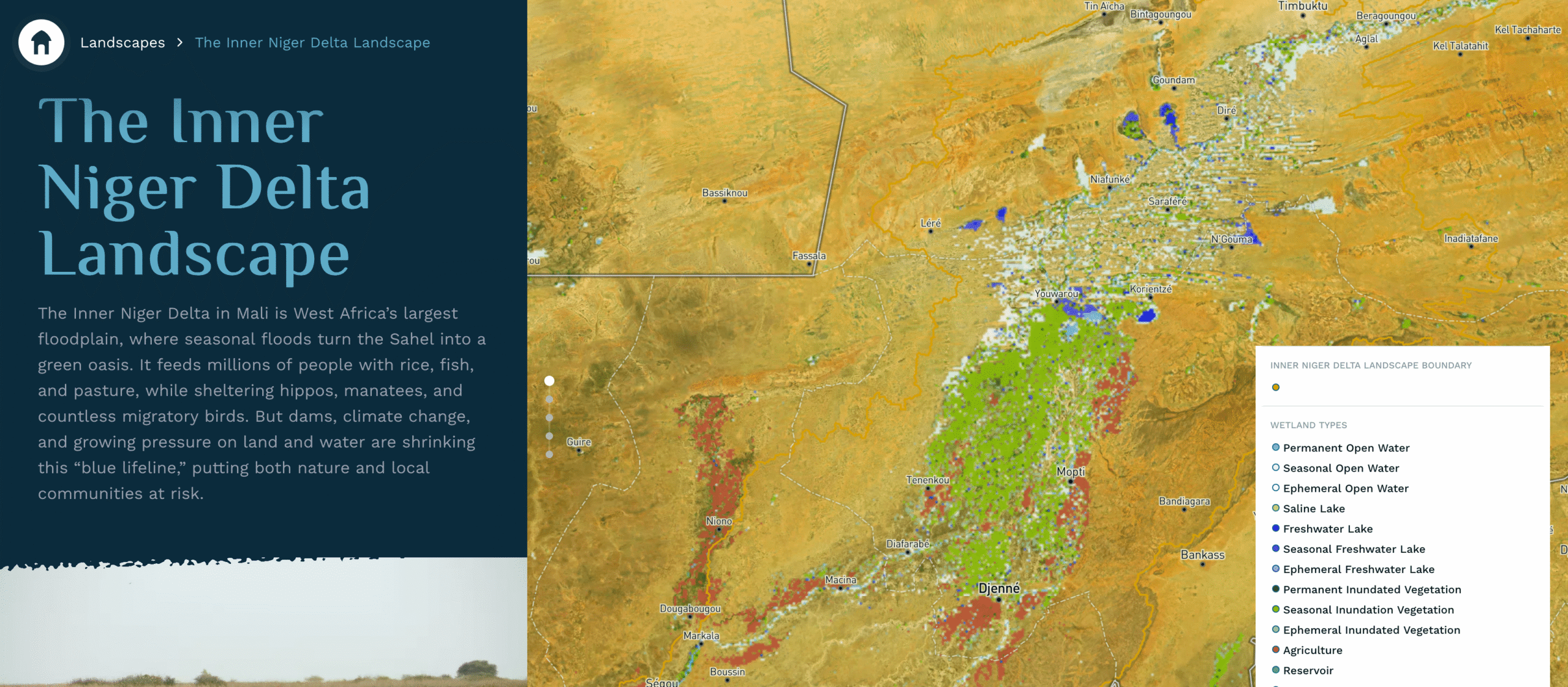
The atlas also highlights important landscapes heavily impacted by wetlands, such as Mali’s Inner Niger Delta, West Africa’s largest floodplain. Seasonal floods in the delta, known as a “blue lifeline,” turn the Sahel into an oasis that feeds millions of people with fish and rice and offers habitat to hippos, manatees and migratory birds. The platform also identifies threats to the delta, including from upstream dams and climate change.
“By making these dimensions visible, the Wetland Atlas helps position wetland conservation as an investment opportunity rather than just a cost,” Michael Nelemans, Wetland Atlas coordinator, told Mongabay by email.
Nelemans added that the team chose to start with the Sahel and the Horn of Africa region because both “remain underrepresented in terms of accessible, integrated data,” despite the vulnerability of their wetlands.
“Wetlands International also has a strong operational presence in these regions, which allowed us to validate data and engage directly with users,” he said.
Expansion of the atlas to other regions will depend on the availability and quality of baseline datasets, Nelemans said.
Banner image: A screenshot image of the Inner Niger Delta Landscape displayed for users navigating the Wetland Atlas, courtesy of Wetlands International.