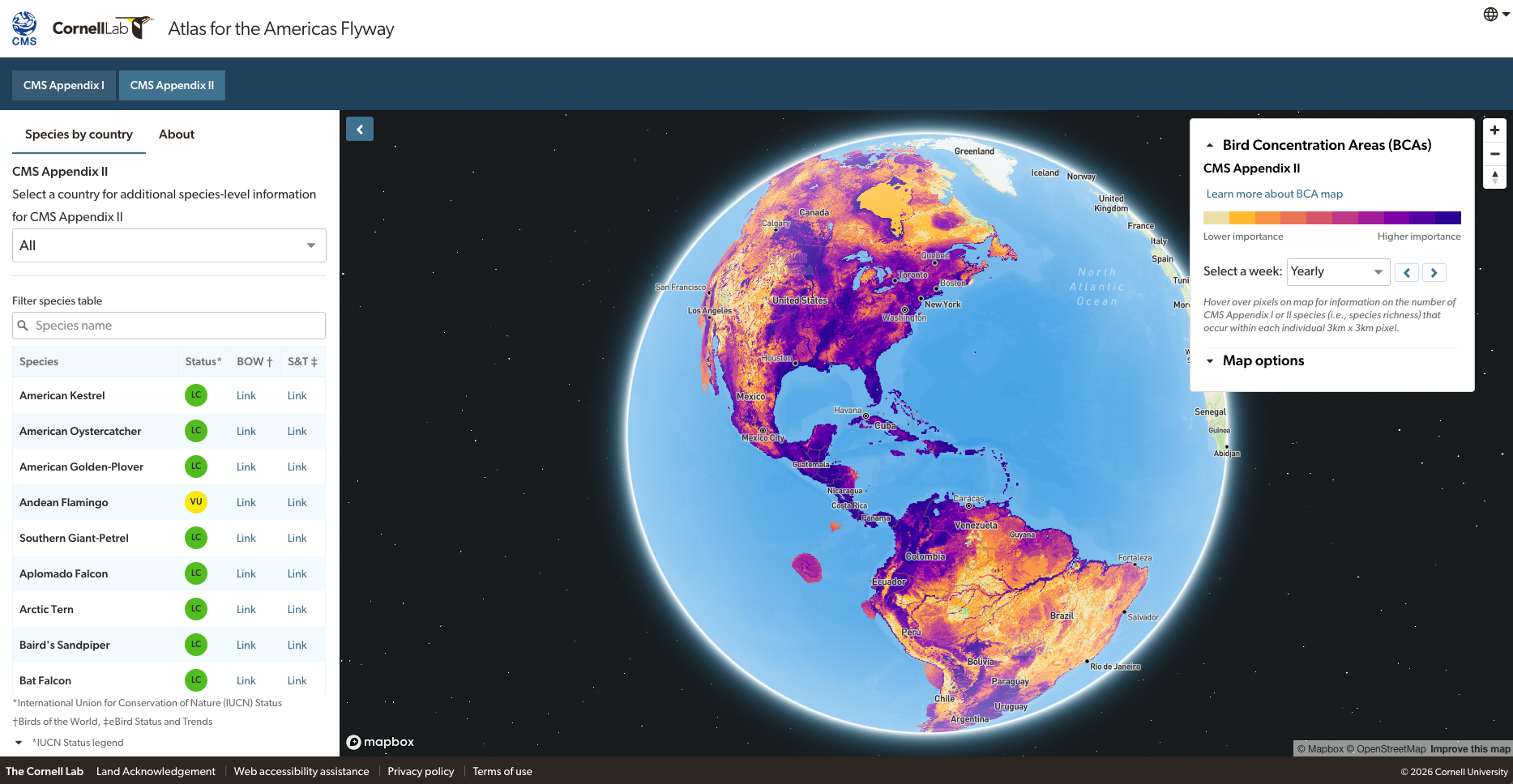
- A newly released “Atlas for the Americas Flyways” tracks the high concentrations of 89 migratory bird species that are at risk of major population decline throughout the western hemisphere. It identifies their breeding grounds, wintering areas and stopover locations.
- This marks the first time these hemispheric migratory routes have been mapped in such extreme detail. Hyper-specific location data aim to provide policymakers, conservationists and others with the necessary tools to make informed decisions about protecting migratory bird species all along their flyways.
- The atlas highlights migratory connectivity — identifying key locations in North, Central and South America. Maintaining the environmental integrity of these places is critical to supporting migratory species and includes many tropical hotspots such as Mexico’s Yucatán Peninsula and the Pantanal wetland in Brazil and Paraguay.
- The atlas will also be of use to researchers trying to understand why a species’ population is declining. It can also help planners mitigate perilous threats by providing geographical data as to where, and where not, to build infrastructure.
Announced at the end of March, the “Atlas for the Americas Flyways” website tracks high concentrations of migratory bird species at risk of major population declines along their routes throughout the Americas.
This new United Nations-backed tool identifies heavily trafficked breeding grounds, migratory stopover locations and wintering areas, with the aim of providing policymakers and conservationists with actionable, location-based guidance on where and how to protect and conserve these species.
It closely tracks 89 at-risk migratory bird species out of the 622 that traverse North, Central and South America. Available for everyone to explore, the atlas presents a useful, fascinating and fun opportunity to explore the annual journeys of these birds.
The atlas was developed by researchers at the Cornell Lab of Ornithology and the Convention on the Conservation of Migratory Species of Wild Animals (CMS). Its mapping spans the 56 countries that make up the Americas, explains CMS executive secretary Amy Fraenkel, and focuses on the Atlantic, Pacific and mid-continent flyways.
The mapping tool was created using 20 years of data gathered on the Cornell Lab’s eBird website, an online database and citizen-science project that tracks bird distribution and abundance. Compiling the atlas wouldn’t have been possible, say researchers, without voluntary input from this vast global community of non-scientists.
“This is one of the first times that an intergovernmental agency has promoted the outcomes of participatory science at a really high-level policy manner,” says Tom Auer, an ornithologist at Cornell University who helps manage eBird Status and Trends, and who spoke with Mongabay by phone. “It’s really exciting for people who are participating in these projects to see that the work they do has real-world impact in terms of … policy and how governments make plans.”
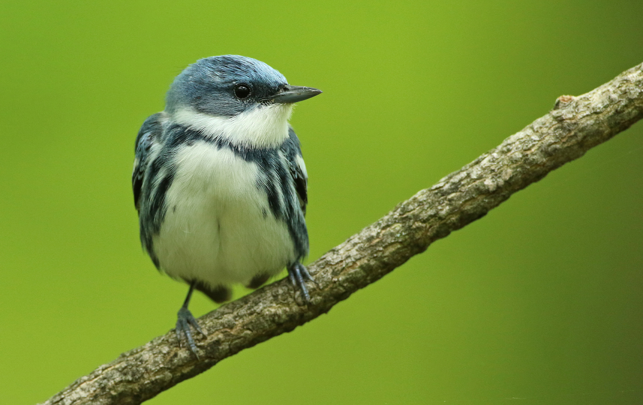
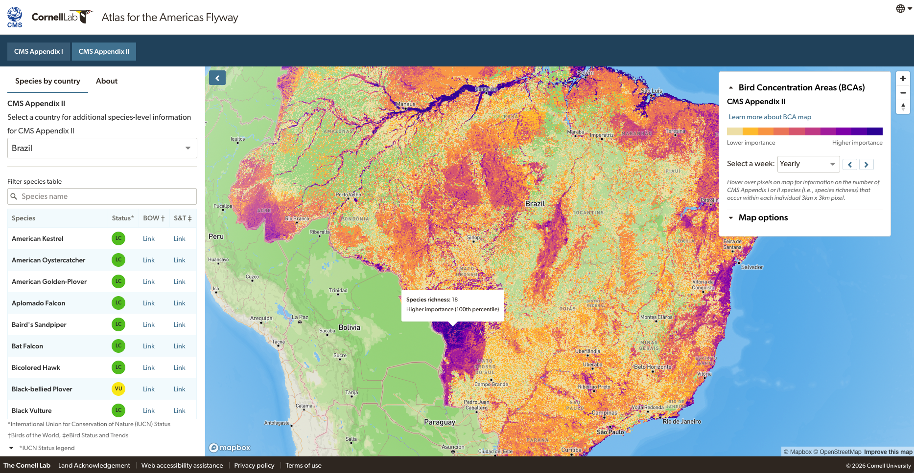
The atlas is made up of two appendices: Appendix I “comprises migratory species … assessed as being in danger of extinction throughout all or a significant portion of their range,” according to the CMS, and it features five species: the Andean flamingo (Phoenicoparrus andinus), buff-breasted sandpiper (Calidris subruficollis), cerulean warbler (Setophaga cerulea), saffron-cowled blackbird (Xanthopsar flavus) and semipalmated sandpiper (Calidris pusilla). Appendix II is made up of 89 “migratory species that have an unfavourable conservation status and that require international agreements for their conservation and management.”
Auer pinpoints Central America as the most integral region for these at-risk migratory species, as it links the two continental land masses via narrower choke points. The atlas specifically zeroes in on the Maya forests of the Yucatán Peninsula, used as wintering grounds and as a northbound migratory pathway for many species.
The Pantanal in Brazil and Paraguay, the world’s largest tropical wetland, is a principal wintering location for Appendix II species. Alaska is also distinctly important, Auer notes, because it’s a breeding area for long-distance migratory birds that nest in the far north and winter in South America.
Researchers say they hope that identifying such hotspots will be of value to policymakers and conservationists seeking ways to protect migratory birds. Habitat loss and degradation account for the largest threat to birds. Society’s need for more agricultural land and timber, along with urbanization of former natural lands to support growing human populations principally explain why 61% of all bird species have declining populations as of 2025, according to BirdLife International , that figure stood at 44% in 2016.
Migratory connectivity ties the Americas together, say the atlas researchers. As birds traverse the continents annually, they use breeding grounds, wintering areas and stopover sites that are sometimes thousands of miles apart. These locales may seem like isolated points. But when seen in the atlas, these points taken together offer a fluent linkage between the many places millions of migrating birds rely on for survival. Viewed this way, these flyway stopping points become extremely important — and also fragile.
“It’s that connection between where they breed and where they spend the winter that really defines their connectivity and then helps you focus and understand what are the threats at different points along the way,” Auer explains.
“What’s really important is understanding how these different places are connected,” agrees Peter Marra, an ornithologist and dean of Georgetown University’s Institute for the Environment and Sustainability, who spoke to Mongabay by phone and wasn’t part of the atlas project. Knowing where migratory birds are exposed to specific threats as they make their journeys is crucial to their conservation, he says.
Auer notes that the atlas offers a hemispheric view of migratory routes and bird abundance not mapped out in such detail before. The spatial resolution of 3 kilometers by 3 kilometers (1.9 by 1.9 miles) can help pinpoint precise locations for policymakers to focus conservation on.
“[P]artner countries could look at the [atlas] together for these groups of species and say, ‘Hey, we’ve got some common spaces here across these species that we share. Let’s prioritize and focus on those places to do work to benefit [these] species,’” Auer says.
The atlas could also help researchers determine the reasons a species is struggling, whether due to hunting, habitat destruction, pollution, or other causes, Fraenkel tells Mongabay. Policymakers, conservationists and planners can also use the hyper-specific geographical data presented in the atlas to know where, and where not, to build. Or if development is a must, efforts could be made to lessen its impacts. The birds are “going to come whether we build or not,” says Fraenkel. “And there are things that can be done to accommodate them.”
Banner image: The cerulean warbler, a near-threatened species, breeds in North America and migrates thousands of miles to winter in the Andes Mountains of South America. It also makes stopovers all along the way. Image courtesy of Luke Seitz via Cornell Lab of Ornithology.
Half of seabirds are declining. Protecting marine flyways could help save them
Citations:
Pucheta, F. M., Pereda, I. M., & Di Giacomo, A. S. (2024). Saffron-cowled blackbirds’ reduced nest success in Argentina’s agricultural land highlights the importance of non-agricultural habitat for its conservation. Ornithological Applications, 126(2). doi:10.1093/ornithapp/duae006
FEEDBACK: Use this form to send a message to the author of this post. If you want to post a public comment, you can do that at the bottom of the page.